


Precinct 2322, Clark County, Nevada
About
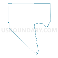
Outline

Summary
| Unique Area Identifier | 614188 |
| Name | Precinct 2322 |
| County | Clark County |
| State | Nevada |
| Area (square miles) | 0.13 |
| Land Area (square miles) | 0.13 |
| Water Area (square miles) | 0.00 |
| % of Land Area | 100.00 |
| % of Water Area | 0.00 |
| Latitude of the Internal Point | 36.22192420 |
| Longtitude of the Internal Point | -115.24451350 |
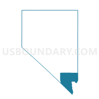
Maps

Graphs
Select a template below for downloading or customizing gragh for Precinct 2322, Clark County, Nevada


Neighbors
Neighoring Voting District (by Name) Neighboring Voting District on the Map
- Precinct 2047, Clark County, NV
- Precinct 2048, Clark County, NV
- Precinct 2104, Clark County, NV
- Precinct 2302, Clark County, NV
- Precinct 2321, Clark County, NV
- Precinct 2323, Clark County, NV
- Precinct 2324, Clark County, NV
- Precinct 2341, Clark County, NV
- Precinct 2342, Clark County, NV
- Precinct 2462, Clark County, NV
Top 10 Neighboring County Subdivision (by Population) Neighboring County Subdivision on the Map
Top 10 Neighboring Place (by Population) Neighboring Place on the Map
Top 10 Neighboring Unified School District (by Population) Neighboring Unified School District on the Map
Top 10 Neighboring State Legislative District Lower Chamber (by Population) Neighboring State Legislative District Lower Chamber on the Map
Top 10 Neighboring State Legislative District Upper Chamber (by Population) Neighboring State Legislative District Upper Chamber on the Map
Top 10 Neighboring 111th Congressional District (by Population) Neighboring 111th Congressional District on the Map
Top 10 Neighboring Census Tract (by Population) Neighboring Census Tract on the Map
- Census Tract 34.15, Clark County, NV (6,384)
- Census Tract 34.12, Clark County, NV (4,420)
- Census Tract 34.11, Clark County, NV (4,037)
- Census Tract 34.16, Clark County, NV (3,041)